Regione Toscana
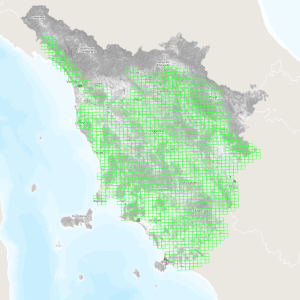
Regione Toscana - Quadro di unione Lidar non di proprietà RT
Quadro di unione (Elementi 1:5000) di dati in formato raster con risoluzione 1x1 m (DTM e DSM) relativi a rilievi LiDAR eseguiti negli anni 2019, 2020 e 2021.
Il sistema di riferimento è quello geodetico nazionale ETRF2000 epoca 2008.0, realizzazione del sistema globale ETRS89, materializzato dalla rete RDN. La rappresentazione cartografica è quella conforme UTM (RDN2008/UTM zone 32N).
La metainformazione del dato LiDAR è disponibile al seguente link https://www502.regione.toscana.it/geoscopio/geometa/html/r_toscan_261ec1b2-bf25-4973-b853-ac08e060ec62.htm
default
metadataInfo
- gmd:characterSet
- UTF8
- organisationName
-
Regione Toscana - Settore Sistema Informativo e Pianificazione del Territorio
- electronicMailAddress
- gmd:dateStamp
- 2025-02-06
- gmd:metadataStandardName
-
Linee Guida RNDT
- gmd:metadataStandardVersion
-
2.0
identificationInfo
- gmd:date (Creation)
- 2023-10-12
- gmd:date (Publication)
- 2023-10-12
- gmd:date (Revision)
- 2023-10-12
- organisationName
-
Regione Toscana
- electronicMailAddress
- datasetcode
-
r_toscan:f3ff89ee-49fa-4487-89fe-c69ae58ecd0c
descriptiveKeywords
-
GEMET
-
-
modello digitale del territorio
-
informazione geo-referenziata
-
freeTextKeywords
- keyword_libera
-
EU
- keyword_libera
-
RNDT
- organisationName
-
Regione Toscana - Settore Sistema Informativo e Pianificazione del Territorio
- electronicMailAddress
rndtDataConstraints
- gmd:useLimitation
-
no conditions apply
accessConstraints
- gmd:accessConstraints
- Other restrictions
- gmd:otherConstraints
- no limitations to public access
useConstraints
- gmd:otherConstraints
-
La risorsa è liberamente accessibile e usabile con licenza CC BY
extent
spatialSection
))
Dataset e serie
metadataInfo
hierarchyLevel
identificationInfo
- gmd:presentationForm
- mapDigital
- gmd:issueIdentification
-
r_toscan:f3ff89ee-49fa-4487-89fe-c69ae58ecd0c
descriptiveKeywords
keyword_inspire_theme
keyword_ambito_territoriale
keyword_opendata
- keyword_opendata_label
-
opendata
- gmd:characterSet
- UTF8
- gmd:spatialRepresentationType
- Vector
- spatialResolutionScale
- 5000
topicCategory
- gmd:topicCategory
-
- imageryBaseMapsEarthCover
- geoscientificInformation
- gmd:supplementalInformation
-
Cod.RT: 155 - QuLidarIRS - f3f
extent
verticalSection
dataQualityInfo
- gmd:level
- Dataset
positionalAccuracy
- gco:Record
- 1
topologicalConsistency
topologicalConsistency
lineage
- gmd:statement
-
Il taglio cartografico è il bounding box, nella proiezione indicata, dell’Elemento quale sessantaquattresima parte del foglio alla scala 1:50.000 nell’inquadramento ED50.
conformitySpecifications
referenceSystems
rsFieldAnchor
rsFieldCCS
rsFieldCode
dataDistribution
gmd:distributionFormat
- format
-
ESRI Shapefile
- format_version
-
1.0
- organisationName
-
Regione Toscana - Settore Sistema Informativo e Pianificazione del Territorio
- electronicMailAddress
onlineResource
- gmd:onLine
- access point ( WWW:LINK-1.0-http--link )
resourceMaintenance
Servizi
metadataInfo
- gmd:hierarchyLevel
- Dataset
serviceIdentification
serviceType
couplingType
operatesOn
operatesOn
dataDistribution
- gmd:onLine
- access point ( WWW:LINK-1.0-http--link )
servicesQualityInfo
qualityLevel
- gmd:level
- Dataset