Regione Toscana
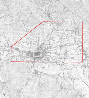
Regione Toscana - Programmazione Rilievi Iperspettrali
File vettoriale che delimita (indicativamente) l'area su cui è in programmazione un Rilievo Ipespettrale (VNIR+SWIR) da piattaforma aerea. Caratteristiche del futuro rilievo iperspetrale:
Regione spettrale misurata - VIS-NIR/-SWIR (380-2500 nm) corrispondente all’estensione degli spettrometri ad immagine iperspettrali imbarcati sul satellite PRISMA.
Bande - almeno pari a quelle di PRISMA (66 nel VNIR, 171 nel SWIR).
Profondità di bit - almeno 12 bit.
Risoluzione spettrale - almeno 5 nm nel VIS
GSD- VNIR=1,5 m SWIR=3 m
default
metadataInfo
- gmd:characterSet
- UTF8
- organisationName
-
Regione Toscana - Settore Sistema Informativo e Pianificazione del Territorio
- electronicMailAddress
- gmd:dateStamp
- 2025-01-14
- gmd:metadataStandardName
-
Linee Guida RNDT
- gmd:metadataStandardVersion
-
2.0
identificationInfo
- gmd:date (Creation)
- 2023-07-01
- gmd:date (Publication)
- 2023-07-01
- organisationName
-
Regione Toscana
- electronicMailAddress
- datasetcode
-
r_toscan:f824ef9b-4ac8-4981-b506-659a664a6068
descriptiveKeywords
-
GEMET
-
-
generale
-
freeTextKeywords
- keyword_libera
-
EU
- keyword_libera
-
RNDT
- organisationName
-
Regione Toscana - Settore Sistema Informativo e Pianificazione del Territorio
- electronicMailAddress
rndtDataConstraints
- gmd:useLimitation
-
no conditions apply
accessConstraints
- gmd:accessConstraints
- Other restrictions
- gmd:otherConstraints
- no limitations to public access
useConstraints
- gmd:otherConstraints
-
La risorsa è liberamente accessibile e usabile con licenza CC BY
extent
spatialSection
))
Dataset e serie
metadataInfo
hierarchyLevel
identificationInfo
- gmd:presentationForm
- mapDigital
- gmd:issueIdentification
-
r_toscan:f824ef9b-4ac8-4981-b506-659a664a6068
descriptiveKeywords
keyword_inspire_theme
keyword_ambito_territoriale
keyword_opendata
- keyword_opendata_label
-
opendata
- gmd:characterSet
- UTF8
- gmd:spatialRepresentationType
- Vector
- spatialResolutionScale
- 5000
topicCategory
- gmd:topicCategory
-
- imageryBaseMapsEarthCover
- gmd:supplementalInformation
-
Cod.RT: 154 - RilieviIper - f82
extent
verticalSection
dataQualityInfo
- gmd:level
- Dataset
positionalAccuracy
- gco:Record
- 5
topologicalConsistency
topologicalConsistency
lineage
- gmd:statement
-
File vettoriale poligonale coincidente approssimativamente con l'area presunta del rilievo iperspettrale.
conformitySpecifications
referenceSystems
rsFieldAnchor
rsFieldCCS
rsFieldCode
dataDistribution
gmd:distributionFormat
- format
-
ESRI Shapefile
- format_version
-
1.0
- organisationName
-
Regione Toscana - Settore Sistema Informativo e Pianificazione del Territorio
- electronicMailAddress
onlineResource
- gmd:onLine
- access point ( WWW:LINK-1.0-http--link )
- gmd:onLine
- access point ( WWW:LINK-1.0-http--link )
resourceMaintenance
Servizi
metadataInfo
- gmd:hierarchyLevel
- Dataset
serviceIdentification
serviceType
couplingType
operatesOn
operatesOn
dataDistribution
- gmd:onLine
- access point ( WWW:LINK-1.0-http--link )
- gmd:onLine
- access point ( WWW:LINK-1.0-http--link )
servicesQualityInfo
qualityLevel
- gmd:level
- Dataset